 |
|
|||
|
Pantnagar has a good access to hill stations of Kumaon and Garhwal regions of beautiful Uttaranchal state. The town is a mix of university campus and industrial area. Nainital, Rudrapur and Kiccha, Haldwani are the major cities surrounding Pantnagar. Pantnagar is renowned for having the FIRST agricultural university of India which was established on 17th November, 1960 on an area of 114.40 ha. Previously the university was called the Uttar Pradesh Agricultural University, or Pantnagar University. It is now known as the Govind Ballabh Pant University of Agriculture & Technology. The agricultural university is famous as the birth place of green revolution in the country. A small and remote tourist location, Pantnagar has two main shopping areas namely Badee market (Big market) and Chhoti market (Small market). Gandhi Park and Ambedkar Park are the two main parks in the town. Besides, the diversified population of the town provides a unique charm to the town. Pantnagar is also an ideal base to visit the hill station of Nainital. Before Nov. 2000 Pantnagar was in the Indian state of Uttar Pradesh. However after 9 Nov. 2000 it became part of the new Indian State of Uttarkhand, which is located in the northern part of India and known for its natural beauty. Uttarkhand was carved out of Himalayan and adjoining districts of Uttar Pradesh on 9 November 2000. Pantnagar University was dedicated to the Nation & inaugurated by the first Prime Minister Pt. Jawaharlal Nehru on the 17th of November, 1960. Later the name was changed to Govind Ballabh Pant University of Agriculture and Technology in 1972 to memorialize the great freedom fighter Govind Ballabh Pant. The G.B. Pant University is a symbol of successful partnership between India and the United States. The establishment of this university brought about a revolution in agricultural education, research and extension. It paved the way for setting up of 31 other agricultural universities across the country. For studying AGRICULTURE and VETERINARY SCIENCE Pantnagar University is one of the top institutes with one of the best campuses in INDIA. * College of Agriculture * College of Technology * College of Home Science * College of Basic Science & Humanities * College of Veterinary & Animal Sciences(Veterinary Alumni Society of Pantnagar) * College of Fisheries * College of Agri-Business Management * College of Post Graduate Studies * College of Forestry & Hill Agriculture, Ranichauri, Tehri Garhwal (off-campus) * VCSG College of Horticulture, Bharsar, Pauri Garhwal (off-campus) Pantnagar has a vast lush green area situated in the Tarai region, the foothills of Kumaon Himalayas. Pantnagar geographical coordinates are 29° 3' 0" North, 79° 31' 0" East. Pantnagar is at an altitude of 243.84 MSL. It is situated on the banks of the Gaula river (Gaula River is approximately 500 kilometers long. It originates in the Sattal lakes, and flows south past Pantnagar) The Research Centre experiences subtropical and humid climate. The maximum temperature ranges 35-45°c. and the minimum between 2-5°c. The average rainfall is 1350 mm. Pantnagar Railway Station Station Code :- PBW Arrival and Departure Enquiry 05944 - 233539 Pantnagar railway station is situated on the Lucknow Bareily Lalkuan section of North Eastern Railways. The railway station is served by express trains from Lucknow, Agra and other places of the country. Nainital Express and Kumaon Express connect Pantnagar with Lucknow and Agra respectively. The bus stand is located close to the railway station from where buses ply for Nainital, Ranikhet, Moradabad, Bareilly and many other destinations. Kumaon Express and Nainital Express connect Pantnagar with Agra and Lucknow respectively. Amenities available at Pantnagar railway station include waiting room, retiring room, refreshment room, water cooler, tea stall and telephone booth. Distances of major landmarks Airport (3 km), Nainital (65 km), Bareilly (75 km), Moradabad (90 km), Delhi (250 km), Lucknow (360 km). Pantnagar is a town and a University campus in Udham Singh Nagar district, Uttarakhand.  In recent years, an Integrated Industrial estate has been established near the campus which houses various companies such as Tata, Bajaj, Nestle, and Dabur. Pantnagar Airport is a domestic airport that serves the town of Pantnagar in the north Indian state of Uttarakhand that is operated by the Airports Authority of India. The airstrip was able to accommodate only small aircraft until 2008, when the length of the runway was increased to 4,500 feet to accommodate larger tourbo-prop aircraft at the cost of Rs. 75 crore. Pantnagar Airport has 4 conveyor belts. It is the nearest airport to the hill stations of Nainital (65 km), Bhimtal (50 km), Ranikhet (110 km) and Almora (120 km) and the Jim Corbett National Park (120 km). Between 2005 and 2008, the Government of Uttarakhand offered a subsidy to Jagson Airlines to undertake a scheduled flight between Pantnagar and New Delhi. The airline uses an 18 seater Dornier 228 on the route. This was however withdrawn in 2008 when the runway size was increased. The government then invited Deccan Aviation to fly on the Delhi - Pantnagar route. Kingfisher Airlines, which took over Deccan Aviation, undertakes seasonal flights to Pantnagar as the weather does not allow it to fly around the year. Airlines and Destinations Jagson Airlines - Delhi
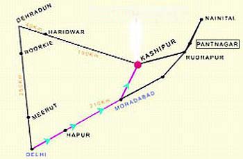
Nainital to Pantnagar Distance - Pantnagar Distance Nainital is 65 Kms Pantnagar to Haldwani Distance is 40 Kms Pantnagar to Bhimtal Distance is 50 Kms Pantnagar to Ranikhet Distance is 110 Kms Pantnagar to Bareilly Distance is 75 Kms Pantnagar to Moradabad Distance is 90 Kms Pantnagar to Delhi Distance is 250 Kms Pantnagar to Lucknow Distance is 360 Kms Pantnagar to Almora Distance is 120 Kms Pantnagar to Corbet National Park Distance is 120 Kms Pantnagar to Kathgodam Distance is 46 Kms Haridwar to Pantnagar Distance is 205 Kms Dehradun to Pantnagar Distance is 265 Kms Rudrapur to Pantnagar Distance is 15 Kms Delhi to Pantnagar Distance is 250 Kms
Nainital Tourism offers Pickup & Drop facility + online booking for various Hotels & Resorts in Nainital District & Uttarakhand.
|
| Nainital Tourism offers Transport & Online Booking for various Hotels & Resorts in Uttarakhand |
|
|||||||